Baluardo San Benedetto, subsequently Barriere
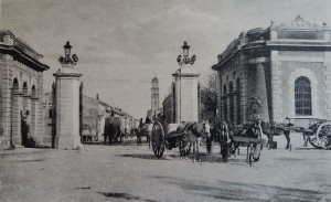
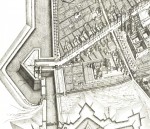
Nothing remains of the late-fifteenth-century military structure, modified several times during the following century. Likewise, the bombardments of WWII erased all traces of the nineteenth-century Barriere.
Historical notes
Completed in 1497, the ancient Porta di San Benedetto overlooked the main western entrance to Ferrara, located at the end of the long decumanus in the Addizione Erculea (Erculean Addition) quarter, i.e. the present-day route of Porta Po-Biagio Rossetti-Porta Mare. It was modified between 1514 and 1521, with the addition of a triangular bastion in front of it, designed by an engineer named Sebastiano Bonmartini from Monselice. It was further transformed in 1582 during the Signoria (Lordship) of Alfonso II d'Este, to protect the gateway of the same name, subsequently dubbed Porta Po by the French in 1798.
The entire building was demolished in 1846 to make room for the two customs barriers (called the ‘quatar garidun’, the ‘four bedside cabinets’) placed at the confluence of the city's two main roads: present-day Corso Porta Po and Viale Cavour, the latter built upon the old route of the famous Canale Panfilio (Panfilio Canal), definitively filled in between 1865 and 1880.
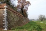
It should be mentioned that, in the 1940s, people within the city and beyond began to discuss the possibility of entirely demolishing the section of wall between the Barriere and the former fortress's bastions of Santa Maria and San Paolo, deemed to be of little value and an obstacle to urban expansion. Just a few years later, the ‘Industrial Zone in the Municipality of Ferrara’ was created (Royal Decree of 26 December 1936-XIV) in the area to the north-west, west and south-west, including the parts between the Po, the Ferrara-Padua trunk road, the Biocelli canal, the Volano (with a new dock), the Ferrara-Bologna road, the extension of old city walls, Viale Battisti and Via San Giacomo.
Following the damage caused by the bombardments of 1944, the customs barriers were also demolished in 1951 and, in the following decade, the entire south-western curtain wall was knocked down in several places to make way for roads that lead to the railway station. Later on - and causing its fair share of controversy - the imposing residential buildings surrounding it led to the most serious blows to the city walls.
The Panfilio Canal
The canal that linked Ferrara and Pontelagoscuro until 1645 was called the Cavo del Barco; in honour of Pope Innocent X (Giovanni Battista Pamphilj), it took on the name of Canale Panfilio (the Panfilio Canal). Until 1647, boats that crossed the Cavo del Barco didn’t enter the centre of Ferrara. Rather, they were forced to stop at the Porta di San Benedetto since, from that point until the castle, the old ditch of the ducal gardens (Cavo dei Giardini) was no longer navigable, crossed by four bridges: Violino, San Gabriele, Santa Lucia and della Rosa. Cardinal Legate Giovanni Stefano Donghi was the one to dig the riverbed between the end of 1644 and 1645. Contemporaneously, he also rebuilt the embankments of the ditch that extended from Porta San Benedetto to the castle, making it navigable.
Considering the serious hygienic risks of the increasingly putrid waters, in 1840 the municipal authorities were ever more convinced that it was best to fill in the canal and replace it with a spacious urban road that would feed into Corso Giovecca. The plan also included the modernisation and expansion of the roadways near the Barriera di Porta Po, to make it easier to enter the city. Work finally began in 1861 and, by 1865, the road and the ditch were packed with dirt up to Corso Isonzo. Only in 1880 was work completed, naming the road after Camillo Benso, Count of Cavour.
Bibliography
Sitography
- https://www.ottocentoferrarese.it/dizionario-storico-dellottocento-ferrarese/indice-alfabetico/item/54.html
Fototeca
Related Themes
Compiling entity
- Assessorato alla Cultura e al Turismo, Comune di Ferrara


